
Page 24 - 19BAR0006
P. 24
4. SITE SELECTION AND ANALYSIS
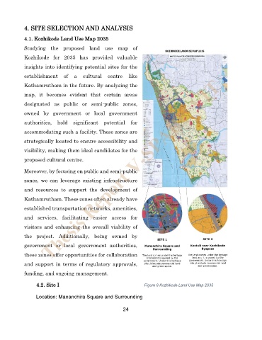
4.1. Kozhikode Land Use Map 2035
Studying the proposed land use map of
Kozhikode for 2035 has provided valuable
insights into identifying potential sites for the
establishment of a cultural centre like
Thesis Report V-SPARC VIT
Kathamrutham in the future. By analysing the
map, it becomes evident that certain areas
designated as public or semi-public zones,
owned by government or local government
authorities, hold significant potential for
accommodating such a facility. These zones are
strategically located to ensure accessibility and
visibility, making them ideal candidates for the
proposed cultural centre.
Moreover, by focusing on public and semi-public
zones, we can leverage existing infrastructure
and resources to support the development of
Kathamrutham. These zones often already have
established transportation networks, amenities,
and services, facilitating easier access for
visitors and enhancing the overall viability of
the project. Additionally, being owned by
government or local government authorities,
these zones offer opportunities for collaboration
and support in terms of regulatory approvals,
funding, and ongoing management.
4.2. Site I Figure 8 Kozhikode Land Use Map 2035
Location: Mananchira Square and Surrounding
24